Trailwalker, to me it is synonymous to hiking to the extreme and putting yourself in harm's way for no good reason. 4 years ago when I met PL, he told me he completed the course under 30 hours but he had to go directly to the hospital afterwards. I remember thinking to myself, how could you talk overnight and then finish the race only to check yourself in the hospital?! I mean, are these people nuts?
Well, at least, my conclusion was that we should at least try it once in our lifetime. It is there so you could give yourself an ultimate challenge. To me, this ranks up there with finishing a full Marathon, or getting to the base camp of Everest, or crossing the Sahara, roughing it on the Silk Road, getting to the South Pole, etc. So, we just have to start somewhere on that list...
Well, hey, either I'm getting old, or I feel like a major challenge, so I have committed myself to this year's Trailwalker, to be held in early November.
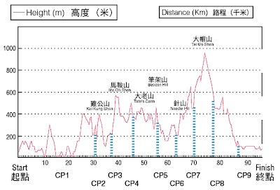
As you could see on the map above, Trailwalker takes the route of the MacLehose Trail, completed and opened on 26.10.1979 under Governor MacLehose's administration between 1971 to 1982. The "M-Trail" is the longest hiking trail in the Territory, taking you from the eastern-most parts of the New Territories in Sai Kung, through Ma On Shan, Lion Rock, Beacon Hill, Shing Mun Reservoir, Tai Mo Shan, Tai Lam Chung, to Tuen Mun. 100km (~60miles) of up and down, all-around hiking through heavy woods, lush meadows, breath-taking vistas, secluded beaches, and deserted villages. Sounds like fun, doesn't it? Well, first check out the gradient changes in the following diagram. Scary, eh?

In preparation of Trailwalker 2008, our team finally began training on the actual trail.
Last week we took on what seems to be the toughest stages, which are 4 and 5, from Shui Long Wo (水浪窩) in Sai Kung, via Tate's Cairn (大老山) and the back of Lion Rock (獅子山), to Tai Po Highway (大埔道).
Though not an expert hiker, these 8+ hour hikes are a real killer on my shoulders, back, and of course, legs and feet. Can't even imagine what it'd be like when you link them all up and do 30+ hours at one go. I was COMPLETELY exhausted after this first hike, and frankly it was a bit too much for me. The massage I got afterwards was more than necessary, but for the following 2 days I was compeltely lethargic and I walked funny. haha.
Well, at least I got to do some shopping... Ever since confirming my participation, I've begun getting the right kind of accessories... new hiking pants, socks, wind breaker, t-shirts, and yes, underwear. Do you know that when the insides of your thighs rub against each other for hours, with sweat mixed between, the burning sensation can be really unbearable? And there are other areas where it could be a problem as well...
(What I heard is, Vaseline is a real miracle for this problem... note to self, gotta get Vaseline)
So this past Sunday, we tackled another tough section, which is from the end of Stage 1, i.e. the end of East Dam of Highland Reservoir, to the end of Stage 3 at Shui Long Wo (水浪窩) in Sai Kung, via many serene beaches and high hills in Sai Kung. Really breath-taking and tranquil.
Thanks to our training on the previous week, I think we are better prepared and better paced this time, so at the end of the hike I didn't feel so bad!My other teammates have done this 4, 5 times already, so finishing the trail would not be a new thing for them. Of course I want to do this within a decent amount of time, but I should really focus now on the idea of not sleeping for 30+ hours and walking from Sai Kung to Tuen Mun. Sounds ridiculous, doesn't it?
1. Looking up Ma On Shan
2. Walking along the ridge after Ma On Shan
3. Beautifully paved trail with big boulders
4. A glimpse of Lion Rock as we made our way towards Beacon Hill
(From 19.10.2008)
- East Dam of Highland Reservoir... looks like the moonscape, doesn't it?
- Nam She Peak (蚺蛇尖) on the left, one of the most difficult peaks to climb in all of HK, as seen from Sai Wan Shan (西灣山)
- Ham Tin Wan (鹹田灣) with Nam She Peak in the background
4. Looking out to the ocean, what a beautiful day!
5. Looking from Ngau Yee Shek Shan (牛耳石山) at Kai Kung Shan (雞公山) in the foreground and Ma On Shan in the distance
6. Lui Ta Shek (雷打石) from the bottom, if you look closely you will see two big boulders sitting on the side of the hill.


2 comments:
thx 4 submitting the paper in due course :)
damn rite about the underwear thing ... have been there after hours of badminton or hiking when I was much fatter years ago (LOL)
would take leaves b4 and/or after the walk?
Still trying to solve this underwear problem... well in fact it's really not an underwear problem... (*wink*)
I don't have many leave days left ah... just the actual days jar...
Post a Comment