Sunday, November 16, 2008

Trailwalker 毅行者 2008 (1)

原來自己比想象中tough.

查實兩個多月的訓練,都算為自己的體能作了一個很好的評估。。。

上山是ok的。

下山比較討厭,因自己負荷大(我體重不輕),所以對膝頭壓力不少。


對我來講原來通宵不眠才是最大的考驗。

我們上星期五早上11點起步,在風和日麗的環境下,與其他三千多個毅行者從北潭涌出發。出發點是保良局度假營。記得很久以前第一次來這個地方是跟很多親戚一塊兒來的。然後小學都試過來這兒作school picnic (話時話要un兩個鐘車從中環到西貢picnic爲什麽?我記得回程時我有嘔的)。


Anyway,我們38個小時的旅程就在北潭涌開始。


1. 2.
3.

1. Start of Trailwalker at Po Leung Kuk Holiday Camp at Pak Tam Chung
2. End the trail around Highland Reservoir at East Dam
3. The first hill up and then down to Long Ke

攀過浪茄、西灣山,我們隊長身體有點不對。其實,當天的氣溫實在溫暖,而且太陽高照,上西灣山的一段就是很多人癩野的地方。可能就是隊長沒有喝足夠的水分,所以到西灣亭時辛苦到不得了。往後他唯有慢慢支持到西灣村,即Check Point #1,補充體力,食個餐蛋麪,繼續向北潭凹(CP 2)進發。

大浪坳 - 赤徑 - 牛湖墩都是上上落落的一段,雖然登山的路段不大困難,但始終都是從大浪坳落山到水平綫上的赤徑,然後在急攀上海拔400米的高度。所以,隊長在傍晚到達北潭凹時決定退出,但希望小休之後可以在CP3(企嶺下/水浪窩)可以陪我們完成餘下的路段。

就這樣,我們繼續向第3段推進。根據之前訓練的經驗,第3、4、5段是100km的路程裏面最困難的路段。由於已經入黑,所以山就麻木的攀,有路就行。半夜前(先在嶂上食了碗豆腐花,hehe)越過雞公山到達CP3(企嶺下/水浪窩),與Support Team會合,而隊長亦已經恢復體力,換過衫,非常refresh。我們經過Support Team的呵護,換襪、換under、換衫,再次踏上征途,向馬鞍山進發。有人問入夜行上會否害怕?事實是,當晚有超過3千人通山跑,壯觀的是在山上可以看到一條長長的燈龍。。。一位每個人的頭上有頭燈或手持手電,所以從山下往上山,整個山頭都是一點點的光。Feels quite special。

4. 5.

4. CP1 at Sai Wan Tsuen

5. Tofu Fa at Cheung Sheung


雖然馬鞍山是很大的挑戰,但到睡覺時間,人已經開始有點神志不清。只有跟著前面的步伐,一步步往上行。馬鞍山過了,昂平、茅坪、打瀉油坳都順利完成。自己是第一個到達基維爾營地(CP4),記得有沐浴設施的,便不理三七二十一沖了個熱水涼。。。哇,當時的感覺是在無敵!感覺就好像剛剛從沙漠出來,滿身是沙塵,在bath tub 浸個浴。。。呢呢呢,好似Ralph Fiennes 在 "The English Patient" 裏面一樣,哈哈。

Anyway,由於已經早上5點,實在很悃,而且有點涼,而隊長亦應要求讓我們hup 15 分鐘。那我們就在浴室外的石屎地上休息了15分鐘了。

(大會在每個CP預備了不同的飲料及食物,包括我摯愛的Ovaltine及花生醬夾麵包。也有蘑菇湯、番茄湯、葁茶、咖啡等)


6. 7.
8.
6. Rest Stop at CP3 (Shui Long Wo)
7. Checking in at CP3 with Firemen volunteers
8. Still 69km to go!

往後的3個鐘,就是在天就光的時段向沙田坳推進。在沙田坳食過麪後,在9點前到達筆架山(CP5)。由於天朗氣清,登上筆架山前可以欣賞整個在獅子山下九龍的全景。啓德早晨!又一村早晨!九龍塘早晨!

9. 10.

9. After snack at Shatin Pass

10. Panoramic view over Kowloon


大埔道是我們Support Team的第二個支援點,很累、很肚餓、很髒,總之辛苦。
又訓、又食、又換衫,今次還有按摩。。。哇簡直一流。。。在和暖的陽光下訓了20分鐘,精神爲之一振。


11. 12.

11. Sleep deprived... so had to take a small nap

12. On we go again after CP6

(TO BE CONTINUED...)

Wednesday, November 12, 2008

A Never-ending Hike


Descending from Grass Hill (草山) to Lead Mine Pass (鉛礦凹), before climbing up Tai Mo Shan (957m), which could be seen here on the upper left hand corner. Photo taken by teammate at 3:27pm on 8.11.2008, still 10 hours to go before our finish.

Monday, November 10, 2008

I Had a Dream


... in which I scaled the tallest peaks in Hong Kong,

saw shooting stars in a cloudless sky,

faced the cold north wind over ridgelines,

admired my beloved City at night,

chowed down energy bars as snacks,

and going non-stop for a day and a half...

#($*&!*(@(#!@

Wait a minute, that wasn't a dream,

that's what I was doing for over 38 hours.


Thursday, November 06, 2008

D-1


Track our progress

Wednesday, November 05, 2008

The 44th President of the United States of America


Called by Yahoo! and the SF Chronicle (among others) at 8:19pm PST...


Tuesday, November 04, 2008

Monday, November 03, 2008

D-6

Cloudy panoramic view from Jardine's Lookout


Two months of training covered 95% of the actual MacLehose Trail, sections of Wilson Trail, 99% of Hong Kong Trail. This is the most hiking I've ever done in a season, and the grand daddy of it all is still coming... in 4 days.


So, on D-6 (Nov 1), we did the 2nd half of Hong Kong Trail, picking up from where we left off more than a month ago, from Parkview, through Jardine's Lookout, Mount Bulter, Tai Tam Reservoir, To Di Wan, Dragon's Back, and diverted to Siu Sai Wan through Pottinger Gap and Pottinger Peak and Cape Collinson.

These make up Stages 5 to 8 of Hong Kong Trail. I've done the first two sections alot. The last one was quite memorable, as AM, MM, H, and I stumbled upon a new explosives depot at the base of the Jardine's Lookout Quarry... well, the rest is, let's just say, history. Another time I did it with a whole bunch of people, gosh there must be over 10 people. I do remember one guy (whom I don't know so well) walked from Parkview to the tip of Jardine's Lookout, only to turn back to Parkview when we began the descend down to the quarry... you ask me why? He said he's afraid of heights.

The hike between Tai Tam Reservoir and To Di Wan (土地灣) was very boring as you walk along this catchwater for about 7km (like... 2 hours?). You do get a little bit of a view overlooking Tai Tam Bay and Redhill (紅山半島). There's a Hobie Club there and from operator, it seems a popular spot for ex-pats.

土地灣, end of Stage 7 of Hong Kong Trail,
藍記士多 selling drinks and noodles open on weekends

Dragon's Back (龍脊) along mountain ridges

Stage 8 of HK Trail features a very well-known section called "Dragon's Back". I remember it was last year when AM decided to lead a group hike there... about 8 of us again. Then we hiked up from the bus stop above 土地灣, walked across the hill half way up, and about an hour later, we ended up at the same spot where we began... Clearly somebody didn't do their homework, hahaha. Anyway, this time I finally got to this section which Time Magazine declared in 2004 the Best Urban Hike in Asia. It was a bit drizzly and windy on Saturday, but the view towards both sides of the Dragon's Back is quite amazing. One the right you have the ultra-exclusive Shek O Road/Big Wave Bay Road (石澳道/大浪灣道) houses as well as an enclave of villas at Shek O Headland (石澳山仔); and on the left you have the highrises of Tai Tam, clusters of houses on Redhill and Tai Tam Road as well as a distant view of Stanley and Tung Tau Wan Road (赤柱/東頭灣道). Lots of top properties here on this side of the Island. It's not a difficult hike at all, and compared to the "3 star" rating on MacLehose Trail, thses trails on Hong Kong Island really pales in comparison.

Shek O and Shek O Headland


So anyway, this would be our last preparation for our monumental hike on Friday. Wish me luck, and hopefully I will be able to take some pictures along the way and capture the spirit and excitement of the event.


Picture taken at the Pottinger's Peak Lookout Point looking back at Shek O/Big Wave Bay. This is almost the easternmost point of Hong Kong Island.

Wednesday, October 29, 2008

Sunday, 9:30am


Date: 26.10.2008
Time: 9:30am
Place: Tai Lam Chung Reservoir (Stage 10, MacLehose Trail)

You are looking at a picture taken when I was half awake. No, not because I had to wake up early to catch a bus to Tuen Mun to start the hike, but... in fact, this was the end of our overnight hike which began at Tai Po Road (Stage 6) at 11pm on Saturday. This is by far the most difficult in terms of trying to stay tough and determined through the end, though in terms of difficulty this did not compare with those between Stages 2 and 5.

So we have finally completed (well about 90%) the Trail. Big day comes in 10 days.

Monday, October 20, 2008

Can you spell H-I-K-I-N-G?


After this November, I think I will for sure...

Trailwalker, to me it is synonymous to hiking to the extreme and putting yourself in harm's way for no good reason. 4 years ago when I met PL, he told me he completed the course under 30 hours but he had to go directly to the hospital afterwards. I remember thinking to myself, how could you talk overnight and then finish the race only to check yourself in the hospital?! I mean, are these people nuts?


Well, at least, my conclusion was that we should at least try it once in our lifetime. It is there so you could give yourself an ultimate challenge. To me, this ranks up there with finishing a full Marathon, or getting to the base camp of Everest, or crossing the Sahara, roughing it on the Silk Road, getting to the South Pole, etc. So, we just have to start somewhere on that list...


Well, hey, either I'm getting old, or I feel like a major challenge, so I have committed myself to this year's Trailwalker, to be held in early November.

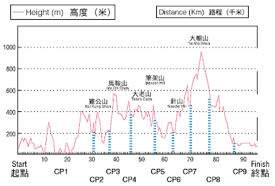
As you could see on the map above, Trailwalker takes the route of the MacLehose Trail, completed and opened on 26.10.1979 under Governor MacLehose's administration between 1971 to 1982. The "M-Trail" is the longest hiking trail in the Territory, taking you from the eastern-most parts of the New Territories in Sai Kung, through Ma On Shan, Lion Rock, Beacon Hill, Shing Mun Reservoir, Tai Mo Shan, Tai Lam Chung, to Tuen Mun. 100km (~60miles) of up and down, all-around hiking through heavy woods, lush meadows, breath-taking vistas, secluded beaches, and deserted villages. Sounds like fun, doesn't it? Well, first check out the gradient changes in the following diagram. Scary, eh?


In preparation of Trailwalker 2008, our team finally began training on the actual trail.

Last week we took on what seems to be the toughest stages, which are 4 and 5, from Shui Long Wo (水浪窩) in Sai Kung, via Tate's Cairn (大老山) and the back of Lion Rock (獅子山), to Tai Po Highway (大埔道).

Though not an expert hiker, these 8+ hour hikes are a real killer on my shoulders, back, and of course, legs and feet. Can't even imagine what it'd be like when you link them all up and do 30+ hours at one go. I was COMPLETELY exhausted after this first hike, and frankly it was a bit too much for me. The massage I got afterwards was more than necessary, but for the following 2 days I was compeltely lethargic and I walked funny. haha.

Well, at least I got to do some shopping... Ever since confirming my participation, I've begun getting the right kind of accessories... new hiking pants, socks, wind breaker, t-shirts, and yes, underwear. Do you know that when the insides of your thighs rub against each other for hours, with sweat mixed between, the burning sensation can be really unbearable? And there are other areas where it could be a problem as well...

(What I heard is, Vaseline is a real miracle for this problem... note to self, gotta get Vaseline)

So this past Sunday, we tackled another tough section, which is from the end of Stage 1, i.e. the end of East Dam of Highland Reservoir, to the end of Stage 3 at Shui Long Wo (水浪窩) in Sai Kung, via many serene beaches and high hills in Sai Kung. Really breath-taking and tranquil.

Thanks to our training on the previous week, I think we are better prepared and better paced this time, so at the end of the hike I didn't feel so bad!


My other teammates have done this 4, 5 times already, so finishing the trail would not be a new thing for them. Of course I want to do this within a decent amount of time, but I should really focus now on the idea of not sleeping for 30+ hours and walking from Sai Kung to Tuen Mun. Sounds ridiculous, doesn't it?

(From 12.10.2008)

1. 2. 3. 4.


1. Looking up Ma On Shan
2. Walking along the ridge after Ma On Shan
3. Beautifully paved trail with big boulders
4. A glimpse of Lion Rock as we made our way towards Beacon Hill


(From 19.10.2008)

1. 2. 3.

  1. East Dam of Highland Reservoir... looks like the moonscape, doesn't it?
  2. Nam She Peak (蚺蛇尖) on the left, one of the most difficult peaks to climb in all of HK, as seen from Sai Wan Shan (西灣山)
  3. Ham Tin Wan (鹹田灣) with Nam She Peak in the background


4. 5. 6.


4. Looking out to the ocean, what a beautiful day!
5. Looking from Ngau Yee Shek Shan (牛耳石山) at Kai Kung Shan (雞公山) in the foreground and Ma On Shan in the distance
6. Lui Ta Shek (雷打石) from the bottom, if you look closely you will see two big boulders sitting on the side of the hill.

Updates

Exhausted again.

This past week has been super busy, with birthdays, official events, and Trailwalker training. Will try to upload some pics later when I am more rested.

Last Sunday we did Stages 4 and 5 of the M-Trail (~23km):
水浪窝 - 马鞍山 - 昂平 - 茅坪 - 打泻油坳 - 基维尔营地 - 大老山 - 沙田坳道 - 沙田坳 - 狮子山(背) - 笔架山 - 鹰巢山 - 大埔道。

Gotta say it was very difficult. Took us about 9 hours from start to finish.

Yesterday we did Stages 2 and 3 (~25km):
万宜水库 - 浪茄 - 西湾山 - 大浪西湾 - 咸田湾 - 大浪坳 - 赤徑 - 牛湖墩 - 北潭凹 - 牛耳石山 - 嶂上 - 雷打石 - 鸡公山 - 水浪窝

Took us another 9 hours. Shxt....

At least now we've tackled the most difficult sections of the M-Trail...

Can't imagine how we'd do all this at one go...

Monday, October 13, 2008

辛苦

全身酸痛
工作加班
劲多工作以外的活动

。。。

十月一向都是最繁忙的。

Friday, October 03, 2008

Thursday, October 02, 2008

點食都係咋糊

(註:以上時間爲Cooridnated Universal Time 協調世界時間/世界標準時間,香港爲UTC+8hrs)

Tuesday, September 30, 2008

Sunday, September 28, 2008

今個秋天要郊遊:第三課


一大早起身,打開窗,有點秋涼的感覺。

未知是時間尚早、還是秋天真的來了。

每年有兩場雨,下完之後天氣會變。。。

五/六月一場,下完之後夏日sauna便會忽然大開。

九/十月一場,下完之後連下午斜陽的色調和氣溫都降至少三至四度。

我想,時間將近了。

今日路綫-港島徑第一至三段,然後寳雲道至跑馬地/銅鑼灣-都頗算熟悉,雖然有些路段未有去過。

路段比先前兩次容易,但今天大家的步伐加快,而且有多段下山路段,小腿很累。

很喜歡從山頂俯瞰維港兩岸,看相罷:


剛巧踫到什麽HSBC Run,好像要沿盧吉道/夏力道圍圈跑兩個圈


圖中間為重建中的樂基山;恆基於2005年以天價1億05百萬收購最後3個單位,完成整個收購項目。重建項目為一座約50層高的頂級豪宅,提供約66個超過3,000平方尺的單位。在政府加入西半山建築高限後,這種摩天住宅重建項目亦即將絕跡。

住過5年的堅尼地城 / 薄扶林 (圖中遠處為大致完成發展的貝沙灣/數碼港)


田灣/香港仔

Saturday, September 27, 2008

是你是我?


Naruto, 呢兩個係兩個唔同既人離ga窩....


等我試多次先:


Friday, September 26, 2008

是我不是我?

What do you think?

好似旺角搬货阿叔。。。

而且更像ogake的大佬。。。

Monday, September 22, 2008

今個秋天要郊遊:第二課

"挑挑"聲(以前所指的“第二挑”)唔好聼,正路來講應該是第二課吧。

第一次晚間遠足,都幾刺激。原來摸黑在叢林裏面走動,比想象中的一樣,就是一步一驚心。沿路聽到不同動物的動靜。好在團隊裏面有個女生,所以有她先尖叫,舒緩了大家緊張的氣氛。

整晚在大潭郊野公園裏面都處走,包括:
黃泥涌峽
紫羅蘭山
淺水灣坳
孖崗山
沿淺水灣道的引水道
淺水灣坳
沿大潭中水塘的山路
大潭水塘道
陽明山莊

其實整個路程的路都行過,尤其是有“天梯”之稱、由淺水灣坳一口氣要爬約950級樓梯到孖崗“第一崗”的路段;因爲以前征服過所以一定不會忘記。亦發覺原來自己比想象fit,真的可以一口氣爬到頂。。。可能要跟同行的隊員“示威”挂,哈哈。

有幾張相可以分享。。。

從紫羅蘭山望向淺水灣道頭段的豪宅群、何氏x太的大屋、香港仔一帶 / 淺水灣主灘


南中國海的夕陽餘暉

前路:950級的天梯 / 從孖崗山回望紫羅蘭山及一眾手下敗將

Wednesday, September 17, 2008

中秋登高

在酷熱警告高掛之下,開始今年的一個新挑戰。


第一挑,元荃古道。約十四公里,由荃灣港鐵站開始,途經荃威花園、石龍拱遠看汀九橋及青馬大橋、田夫仔、清快塘、到大棠南排坑。


希望可以完成任務喇!

開始時回望荃灣一帶 / 遠望汀九

猴頭石見證荃灣的滄桑歲月

破舊古廟,不知是否曾經有乾柴烈火的故事?